When I decided to call Indiana home, I wasn’t lured by the wonderful scenery or natural beauty. Indy was simply the next spot where God had called me to live. What I began to discover, however, is that Indy has plenty of hidden outdoor gems for runners. Check out my recommendations below to discover some of the best spots for trail running near Indianapolis.
- Eagle Creek Park
- Fort Benjamin Harrison
- Marian University trails
- Southwestway Park
- Marrot Park + Holliday Park
Eagle Creek Park
- Location: Northwest side | Website
- Entrance Fee: $7 per vehicle or buy an annual pass for $60.
- Elevation: Challenging for IN. You can get a good 800-1000 ft of gain on a long run of 10-15 miles—more if ya plan it right.
- Mileage: Some trails are as short as a mile; you can string together trails on either side to get to 14+ miles.
The serene “land bridge” at the bottom of Eagle Creek Park’s east side is so beautiful and quiet that you might think you’re by the coast. It’s the perfect reprieve during a long run before you commence running back up toward the top of the park.
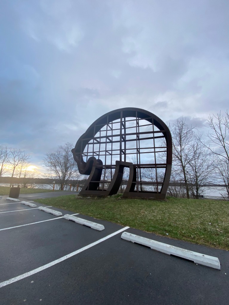
Now, what many don’t know (and I feel a tad guilty sharing) is that the really amazing stuff at Eagle Creek isn’t the 10+ mile trail system that is marked as “Eagle Creek” on Google Maps. Sure, those trails are great; I’ve run them for years. But if you’re looking for something with all the adventure and none of the luxuries (think: signage and port-a-potties), I suggest you cross the Eagle Creek Reservoir and check out the West Side. Marked by a Big Bear statue (see the picture below), there is a single trail that branches off to miles and miles of beautiful running. You’ll find a labyrinth of unpaved trails and some great hills.
Yes, it’s easier to get lost and forget where you’re going. That is exactly why I like it!


Fort Benjamin Harrison
- Location: Northeast side (Lawrence, IN) | Website
- Elevation: Less than Eagle Creek, but decent climbs for Indiana. I’d guesstimate between 200-400 feet of gain depending on your trail and distance.
- Mileage: You can run anywhere from one mile to more than eight miles, all without any repetition. A good long run is definitely possible if you string some trails together. VIEW TRAIL OPTIONS
- Entrance Fee: For Indiana residents (you must have an Indiana license plate), the fee is $7; $9 for out-of-state visitors. An Indiana state park pass will cost $50 for the year.
Wanting to hit Fort Ben? You’ll have to weigh the pros and cons of the seasons. The main loops in the park are open to mountain bikers. While cyclists are supposed to go in the opposite direction as runners, it can still pose a problem for the unsuspecting runner. On the flip side, if you run at Fort Ben in the winter, you may find the trail dizzying without the foliage. While running, you will fold back on yourself dozens of times and it can get a bit monotonous.
The trail is smoother than Eagle Creek though, and it’s harder to get lost. For those looking for a flatter run, Fort Ben provides some rolling hills but is relatively flat.
Marian University trails
- Location: Northwest | Website
- Elevation: If you’re looking for hills, go elsewhere. You’ll only find one.
- Mileage: with no map and a lot of tree coverage, it’s hard to say exactly how long these trails are. Some are as short as a mile, and others are probably a few miles. I’d say you could do some nice loops on the trails and around the campus to get a decent 7 miles in.
- Entrance Fee: None!
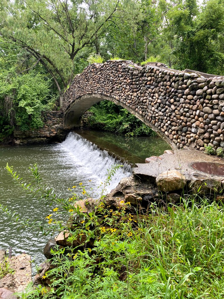
For a small nursing school, Marian has quite an extensive trail system tucked behind its campus. Pick it up by the Major Taylor Velodrome and you’ll quickly go from a smooth path into a forested system of trails (called the EcoLab) that weaves around a lake, football field, and creek bed. I may be biased–my husband and I got engaged on these trails–but it is so quiet and picturesque, and I’m hoping I don’t selfishly regret sharing about this hiding gem. Bonus points if you find all three of the stone bridges that are back there!
Southwestway Park
- Location: Southwest (you guessed it!); just west of Greenwood, IN
- Elevation: Negligible; maybe 200-300 feet of gain.
- Mileage: Up to 11 miles of trails with a few loops that are only a mile or so.
- Entrance Fee: None!

Southwestway takes much longer to drive to than the other parks on this list (about thirty minutes from the northside), but it deserves a shoutout because its distance provides a landscape that’s unique to the usual Indy vibe. Despite being a mountain biking spot, I never find Southwestway very crowded, and the cyclists have always been courteous. I have seen cyclists walking back to the trailhead after breaking an arm though, so be cautious. Whether you’re running or cycling, there are some roots to watch for. It’s more than worth the adventure, though; Southwestway claims to be the third largest park in Indiana and has eleven miles of trails in addition to its playground, picnic shelters, soccer fields, and (no joke) horse stable (horses are allowed on a few of the trails, though I have never seen any).
Marrot Park + Holliday Park

- Location: Northside; Broad Ripple area
- Elevation: You’ll only find a few hills, all within Holliday Park
- Mileage: Plan your route correctly and you can get up to 10 miles, with 90% of it on trails. Shorter loops in both parks are available. On the Strava route below, you can see the trails I discuss. Keep in mind that 7 miles on these trails is more like 8 miles in totality due to tree coverage.
- Entrance Fee: None
Last, but certainly not least, is a trail running adventure that takes a little more planning (or a willingness to get a little lost if need be). People are often ragging on Broad Ripple for being a hipster spot. Perhaps they’re right. But what Broad Ripple has in addition to bars full of college kids, is neat shops and a bakery and lots of adorable dogs….. and trails!


The main stretch of Broad Ripple itself opens up to the canal toepath which–if you follow it down far enough–will actually lead you to the Marian University trails. But that’s not what we’re talking about here. Instead, park at Holliday Park or Marrot Park (can’t go wrong with either). Both parks will shock you with an extensive network of trails. Holliday Park has a few that connect and allow for a couple of miles.
Wanting to go longer? Here’s where navigation skills come in handy. Marrot Park actually begins near where Holliday Park ends toward the south. So, you can run on the Holliday Park trail under the Meridian Street bridge. Here, you have two choices: (1) go over the other side of the bridge and run up on the Levy (grassy trail) that takes you to College Ave. in Broad Ripple OR (2) forage through the woods on a single-track that also heads toward College, but spits you out onto a residential road first. Now, either option also lends itself to a voyage through Marrot Park if you go left/north about a half mile, toward Park Tudor. There, you can jump onto the Marrot Park trails which are extensive but somewhat separated by the river (i.e. if the water level is low, you’ll have to go across the road by ISBVI to access the rest of the trails.
This is a lot of instruction, yes. That’s because there is a lot of adventuring to look forward to! My best tips: Plan ahead, run during daylight, and relax: even if you get lost, you’ll never be more than a quarter mile from a road where cars are.
Bonus points if you find some hidden trails around BR that I haven’t mentioned here. They’re a blast to explore!
Happy trails, friends! Remember to treat your body well. Whether you’re running the mountains of Colorado or the woods of Indiana, there’s a lot to enjoy in nature and caring for your mental and physical health is a way you can ensure you’re around to explore it!
Love,
Hannah

Leave a comment